The area encompassing the HPFMD is rich with fascinating history. From the earliest inhabitants of Native Americans, to the first pioneers and early settlers, the area has stood the test of time as a desirable landscape to put down roots. One of the missions of the District is to preserve this one of a kind location for generations to come.
Good water, plentiful trees, reasonable soil, and an early wagon trail brought energetic people from the overpopulated East to the promising West. They named its High Plains location “the Divide” (short for Palmer Divide and other terms) and its bountiful forests “the Pineries.” A few stopped nearby to rest, some paused to harvest the trees for the gold rush’s boomtown of Denver, and finally others settled down to homestead and farm.
The land that makes up the High Prairie Farms Metro District was once part of a larger area known as The Pinery. While both areas are managed separately their history is interwoven.
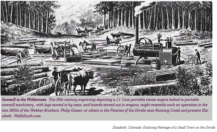
What’s A Pinery?
“While Colorado was still a territory, prospectors and settlers arrived in search of gold. Soon metropolitan Denver became the home for those who found the locality to be valuable as a supply depot for miners seeking their fortune in the foothills west of Denver.”
“To build the homesteads and businesses of pioneer Denver, it was necessary to import all the materials. Wood became a very precious commodity. Settlers arriving on the stagecoach lines southeast of the townsite remembered traveling past forests of Douglas Fir and Ponderosa Pine, ideal wood for building the houses of Denver City, Montana City, Auraria, and Highlands.”
“These forested areas were called ‘Pineries’ and were found along the Cherry Creek. Some of those closest to present-day Parker became the main source of lumber for Denver City. The hillsides of ‘The Pinery” were cleared of all but the youngest saplings in the 1860’s.”
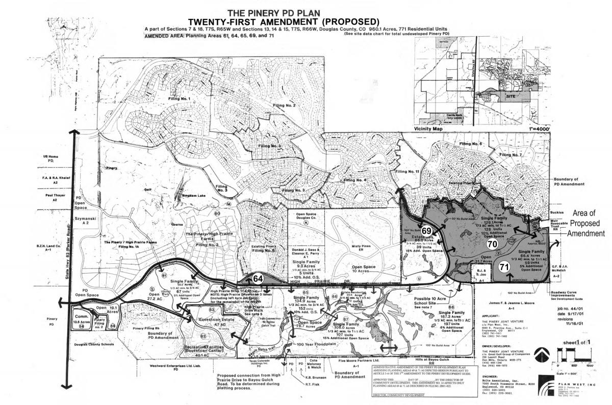
As more people settled in and around Parker, it was inevitable that developers would come upon the scene, offering good prices per acre for the land. The property owners couldn’t resist selling. During the latter half of the 20th century, properties changed hands, and today’s Pinery slowly came into existence.
PINERY & TIMBERS DEVELOPMENT- Terracor and Senior Corp.
“A Utah development corporation announced plans to build a premier housing development on the site of once forested land. To bring people to the homesites, Terracor staged hot-air balloon races in 1976-77 on the knoll where Mountain View Elementary School now stands. Other community events included a bicycle race that challenged contestants on the hills throughout the Pinery.”
“The Pinery development was begun in 1971 but Denver’s soft real estate market forced the developer, Terracor, to declare bankruptcy on November 4, 1982. At that time, the acreage comprising Pinery I was segregated from the undeveloped and unplatted areas of the Pinery.”
“‘Terracor’s successor in interest, Senior Corp., took title to the undeveloped acreage and became the Master Developer for the area.”
Several years later Senior Corp. sold its Pinery holdings to several other builders and developers, including Great Gulf Group which began development of The Timbers at The Pinery. The Timbers now encompasses several filings and makes up a large portion of the High Prairie Farms Metro District.
Did you know the District is home to one of the oldest cemeteries in Colorado?
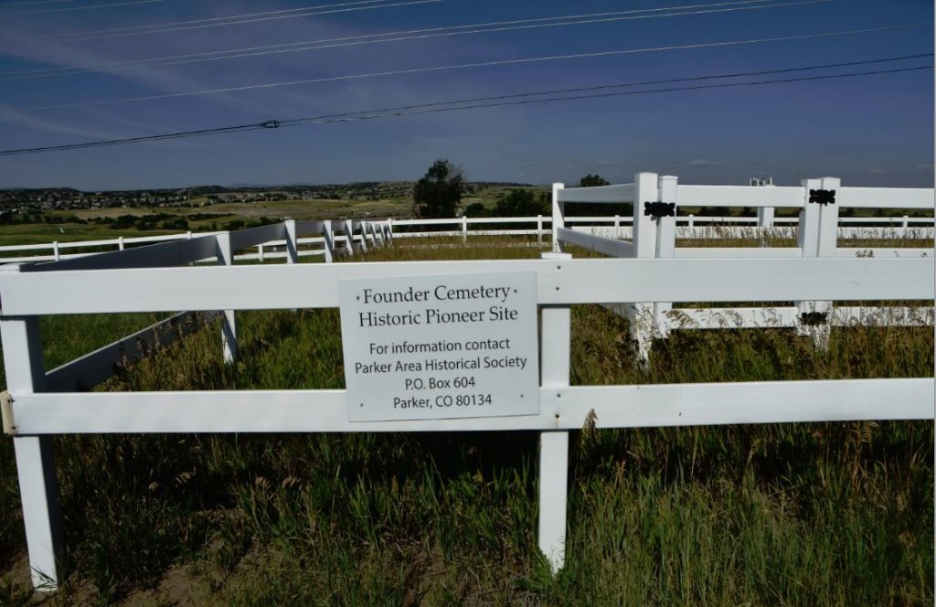
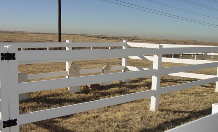
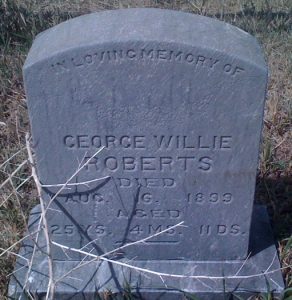
The Eggelston-Fonder-McMurdo Cemetery contains graves that date back to the pioneer era. Initially part of the Eggelston Ranch, the cemetery became known as the Fonder and McMurdo Cemeteries as members of those pioneer families were buried there in the 19th Century. In 1980 the Smoky Hill Chapter of the Daughters of the American Revolution identified 13 legible grave markers, but Parker Area Historical Society researchers and anecdotes suggest many more graves exist.
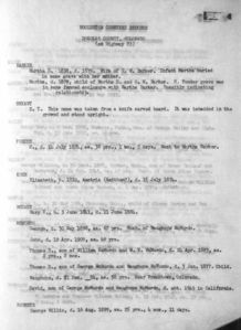
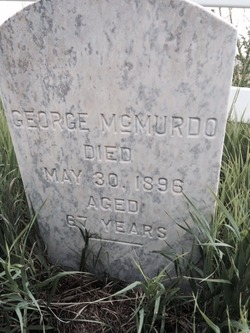
This cemetery was first known as the Eggelston Cemetery; the property was carved out of the Eggelston Ranch, and early news articles refer to it as such. Although he was not the first to be buried there, Hubert Fonder was perhaps the most well-known tenant in its early years. Many people came to refer to it as the Fonder Cemetery. It also became the burial plot of the George McMurdo family, who were early Douglas County pioneers. Thus, it has also been called the McMurdo Cemetery in some writings. The McMurdo family had come from Scotland in the early 1870s and settled in what became known as McMurdo Gulch. The original fence, built in the late 1880s, guarded the spot where seven members of his family lie at rest.
The writings of early residents indicate that there are many more graves than were identified by the 1980 inventory taken. The oldest identified was that of Hubert Fonder, who died in 1871. He was the husband of Miriam Donegan Fonder, who started the Fonder School.
Pioneers Hubert and Miriam Fonder were married in 1862. He was a miner from Belgium and she was from Ohio. They met in Idaho Springs. Hubert joined the army shortly thereafter and Miriam traveled with his battery, acting as laundress for the soldiers. He was discharged in 1865 and they settled on 80 acres, called Shingle Ranch, just west of the current Ponderosa High School.
In 1871, Hubert was killed while trying to break a horse. Hubert is buried in this cemetery. Miriam however lived to the ripe old age of 91, but she was not buried in the cemetery named after them.
The last known burial on the site was in 1955.
In 1990, a local developer owning the surrounding property rebuilt the fence around the little cemetery and in a Memorial Day ceremony, turned over the title to the cemetery to the Parker Area Historical Society. That fence eventually fell apart and it was replaced with a plastic one.
Information for this update came from early family and other resident writings, A Guide to Historic Sites in the Parker Area by F.B. McLaughlin, and Douglas County: A Historical Journey by Josephine Lowell Marr.
https://www.parkerhistory.org/eggleston-cemetery
FONDER SCHOOL
Education was one of the first considerations of settlers. Even before the county was organized a Mrs. Fonder established a school in her home near Franktown. Earliest school records were dated September 1, 1865. By 1890 there were 30 school districts with an enrollment of 612 children. Monthly teacher salaries were $47-55 in rural districts and $44-100 in small towns and Castle Rock.
Denver Public Library
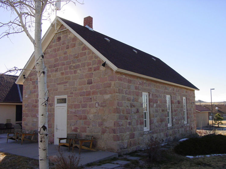
The Fonder School sits just west of District property across Parker Road. Miriam Fonder started the school in her home. Soon, a log schoolhouse was built down on Cherry Creek. Students came from all around the area, including Pine Grove, now Parker. This school became District # 8. The log structure burned in 1884 and was replaced with a more durable structure made of Rhyolite lava stone, quarried from the Plateau Quarry about seven miles west of the school site in Castle Rock. The stone was hauled to the site by oxen belonging to David McMurdo, a local rancher.
The school building had a well for water located to the west, and blackboards lined the walls. Kerosene lamps provided artificial light and a pot-bellied stove provided warmth on cold days. In the early days the windows had shutters, probably to provide protection from Indian attacks, which were numerous. The one-room school had a raised stage platform where the teacher’s desk was placed to provide a commanding view. It could also serve as a place for artful performances. Outside the building was a horse barn which was used to shelter animals the children rode to school, and the boys’ and girls’ outhouses. A cross gable joins two front-gabled wings, one of rubblestone and one half-timbered, flanking the side-lighted entrance. The stone gable end also has a transomed door centered in it, with the lintel inscribed “1883.”
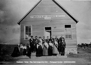
The school house was the center of many social events during the early years, and accommodated various religious activities, club meetings, political meetings and dances. It was the first meeting place for the Fonder Grange in 1875. Details of this Grange can be found on historical site markers in nearby Franktown. It’s successor the Pikes Peak Grange still stands as an event hall south of the District. Through the 1930s, there were dances the first Saturday of each month at Pikes Peak Grange, attended by teenagers from Parker and Elizabeth.
The Fonder school remained in business until it closed in 1949. Its last teacher was Norma Gartrell, a long-time Parker resident. After the school closed, it was used for storage and as a barn. In the early 1970s the building was restored by its owner, then the South Suburban Water & Sanitation District, now the Pinery Water and Waste Water District. At that time an addition to the structure was added for increased office space.
Information for this update, by Larry T. Smith, came from Douglas County by Josephine Lowell Marr, Our Heritage by the Douglas County Historical Society, and A Guide to Historic Sites in Parker by F. B. McLaughlin.
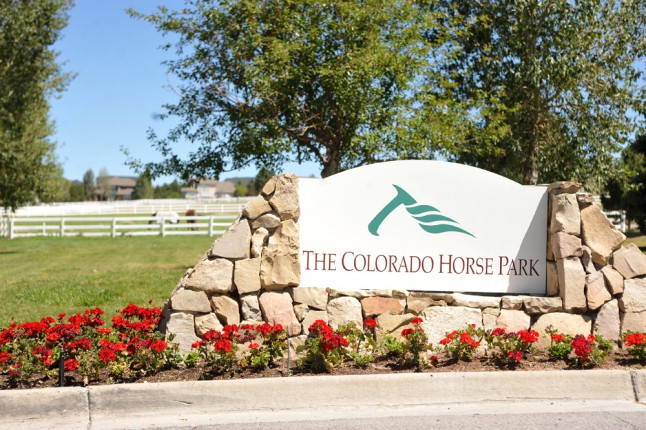
COLORADO HORSE PARK
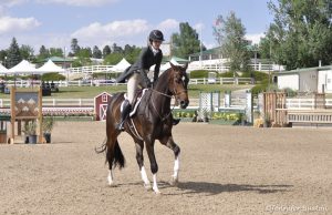
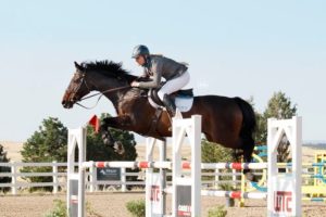
The Colorado Horse Park, originally the High Prairie Farms Equestrian Center, has a prominent place in the District’s history. The iconic white fencing that surrounds a lot of the District was initially part of a larger ranch homestead called High Prairie Farms. This homestead and ranch was purchased by Helen Krieble in an effort to help her daughter gain momentum as a hopeful Olympic horse jumper. Krieble, an equine enthusiast and natural entrepreneur as the daughter of the founder of Loctite Corp., had a vision to turn the property into an international icon of the equestrian world. She spent the next several decades achieving exactly what she had intended, growing the High Prairie Farms Equestrian Center into the largest horse park west of the Mississippi.
Prior to Krieble, original owner of the land Senior Corp., spent $5 million on fencing, barns, a pavilion and an indoor arena to be the centerpiece for an expensive new home community. Krieble purchased this 82 acre farm from Senior Corp. as well as an adjacent 88 acre parcel. She later added another 300 acres of land to the property and the dream continued. The High Prairie Farms Equestrian center grew to offer hands-on educational programming, museum exhibitions, boarding and training, recreation, entertainment, and competitions in several disciplines. It maintained prestigious status as a destination for horse lovers and competitors even hosting Olympic competitions and events while showcasing the heritage and history of the West.
Helen Krieble knew how valuable the horse park could be given the long standing equine history in Douglas county. The Colorado horse industry contributes nearly $1 billion to the gross national product, and the state has the nation’s fourth largest horse population, estimated at 200,000. You can find numerous stables and horseback riding trails dotting the landscape of Douglas and surrounding counties including the quaint bridleways that meander through present day High Prairie Farms. Horses are a keystone of Colorado heritage and Helen knew this from her first visit to the area. In 2014 the horse park was sold to an equine investment group and the name was changed to the Colorado Horse Park which operates today. There were plans for the investment group to open the High Prairie International Polo Club on adjacent acreage but this idea was abandoned and is now the 2 Bridges subdivision.
Through the sale and development of the original homestead purchased by Krieble the current High Prairie Farms neighborhood was constructed thus ensuing the High Prairie Farms Metro District of which the namesake originates. South Pinery Parkway was historically High Prairie Drive until the planned development of the Timbers rerouted Democrat Road to create a loop from North Pinery Parkway, at which point the name was changed. Today you will see the horse head insignia and horse statues adorning the entrances to High Prairie Farms that highlight the homestead’s history and significance in the District.
Detailed history of the area
Long Ago
About 12,000 years ago, man made his appearance. Whether Sandia, Clovis, or Folsom man, time has erased most of his tracks. It is known these early men were in Colorado, hunting numerous animals. These forerunners disappeared about 2,000 years ago, leaving behind some points of their weapons.
The primitive men were followed by the Woodland-Plains Indians, who left an encampment opposite Ponderosa High School, and a dry cave near Franktown, complete with arrow and spear points, moccasins, and other belongings. Even today, the flakes from their manufactured weapons may be found in the Pinery and its surroundings. Made of petrified wood, they are brick-red in color, a sign they were hardened by fire. Shards of crude pottery left by these natives have also been found. The rolling hills around the Pinery allowed the Woodland-Plains families to look out upon the lower vistas to spot enemies or herds of animals. Their location seemed ideal to meet their needs, but they, too, disappeared. Their place was taken by the Arapaho, Cheyenne, and Ute tribes. These “modern” inheritors of early man were witnesses to the arrival of the early settlers in this area of Colorado.
Early Settlers
Early settlers in Pine Grove (Parker) cohabited reasonably well with the Indians. John and Elizabeth Tallman owned property northeast of Parker. The mountain-dwelling Utes frequently crossed their land heading toward hunting grounds. Elizabeth customarily left food for them, so she became a favorite with their chieftains. Jonathan Tallman, John’s brother, wasn’t so lucky in his dealings with Indians. Buried in Parker Cemetery, his headstone reads: “Killed by Indians, 1870.
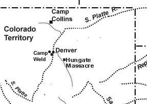
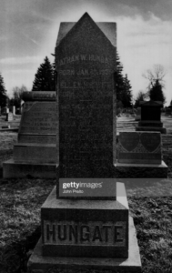
Initially, there were peaceful interactions with Native Americans. Chiefs Washington and Colorow led their tribes along Sulphur Gulch, passing and sometimes visiting cabins of early settlers, like John and Elizabeth Tallman. During one visit, Chief Washington offered up to 20 ponies in trade for their red-headed son. They occasionally heard the sounds of celebration and mourning from nearby encampments. Tension between settlers and Native Americans began to build in the 1860s due to broken treaties, aggression, and cultural misunderstanding. People became especially fearful following the Hungate massacre of 1864 in present-day Elizabeth just south of The Pinery, which is thought to have been prompted by retaliation for Nathan Hungate shooting a Native American who was part of larger scale horse raids occurring in the area.
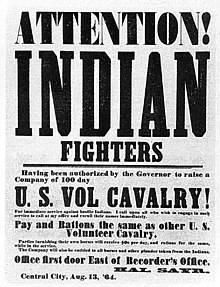
The escalation of tension between these events precipitated the Sand Creek massacre led by General John Chivington later that year. John Tallman was one of the first to arrive at the scene of the Hungate Massacre and he served under Chivington during the Sand Creek massacre. The citizens of Parker became quite concerned and closed the school for a brief time after the massacres. In 1870, Jonathan Tallman (John’s brother) was killed by Native Americans while out riding his mule.
Parker Family
The Parker family, consisting of four brothers and their families, gained prominence. James owned the 20 Mile House Stage Stop; George bought much of the property along Euclid Avenue (Main Street) east of Rte 83, donating some or selling it at reasonable prices to help the town’s growth.
William Rowley owned 160 acres in what has become Stroh Ranch. Later, his family bought 960 acres east of Parker, now known as Rowley Downs. William Newlin at first inhabited the land around Newlin Gulch, but later bought the Tallman property and its cabin. He brought 30 head of short horned cattle to Parker to improve the cattle industry in the area. Newlin Gulch, Parker’s experiment in gold mining, was named for him.
Closer to the future site of the Pinery were Hubert and Miriam Fonder. The Fonder School, now the offices of the Pinery Water and Waste Water District, is located west of South Pinery Parkway. The earliest school in the area, it is also the oldest extant in Douglas County.
Forested areas in the county were called pineries. During the 1860’s, hillsides of the Pinery were denuded of all but the smallest trees to supply building materials for Denver, Auraria, and other developing towns. Nearby sawmills met the demand for finished lumber. The Fonders made shingles in addition to ranching.
An early plat of the area shows the names and land acquisitions of many property owners in the 1800’s. Unfortunately, most shown are west of Rte. 83. The ones to the east are scant. Where North Pinery Parkway and Lakeview Drive now exist, the property had a homestead entry for William Newlin, Jr., son of the aforementioned Newlin family, dated 1884. Acreage just north of that was owned by the Union Pacific Railroad, dated 1892.
Developers Appear
In the pineries, lumber for cabins, buildings, railroad ties, and fuel was cut; the clearing of land for farms and ranches further depleted resources. Fires, floods, and insects also took their toll on the forests. In spite of this ravaging of the trees, General William Larimer, an early Denver developer, blithely declared during an 1858 Christmas celebration at Cherry Creek, “Our pineries are convenient, and will last for generations to come”. During the next 100 years, trees were growing back, reseeded by nature, but not in the density that had given the land its forests. Of the original trees, only some that were saplings in the 1800’s survived.
Despite a 100-year flood in 1864 in the Cherry Creek valley, and a second one in 1965; despite a blizzard in 1858 that piled snow into 20-foot drifts, and the snow of 1913 that overwhelmed everyone with 50-foot drifts, the area around Parker, north of the town and south to Democrat Road, attracted people. The old Cherokee Trail still had traffic through the 1800’s; the stage coach heading into Parker and the 20-Mile House stage stop used it. Freight wagons also caused congestion. The new road, built parallel and to the east of the Cherokee Trail, road number 13, had traffic jams similar to today’s. Residents of that time complained about their traffic, with the slow wagons, livestock being driven to Denver, carriages, and riders on horseback delaying their exiting onto the road. (History does tend to repeat itself!) Farmers and ranchers along road 13 (later Parker Road) had to travel the road to Parker for supplies, but their trips would, of necessity, be infrequent because of chores on their properties that took up their time. The knowledge they acquired through the years about dry farming helped their crops flourish. Tending to them with livestock to care for as well, they had more than enough to do around their acreage.
Over the years more people began to settle in the area and the rest is history…
ADDITIONAL LOCAL AREA HISTORY
Parker Town History
Franktown Cave
History of the town of Elizabeth
Russellville History
Twin Houses